Ridenbaugh Canal Diversion
Brainstorming Ideas for the Ridenbaugh Canal, Headworks Modernization Project
The process of reconstructing an irrigation diversion is substantial because it is a point of inflection when public use turns to private use. Naturally such a diversion of a publicly quantified good to a now privately quantified good causes need for discussion. I hope to bring some thought and further understanding to brainstorm alternatives for the Ridenbaugh Canal Structure. Brainstorming such ideas is great for being able to look back on something and knowingly have anticipated a correct means and methods of achieving an objective.
In this case, objectives would be to enhance public experience with the outdoors, add a unique outdoor experience, divert enough water to meet private water right class, provide fish habitat, provide bird habitat, receive Federal and State permitting, and be able to be used at all river flows. Many design criteria must be weighed and thought of.
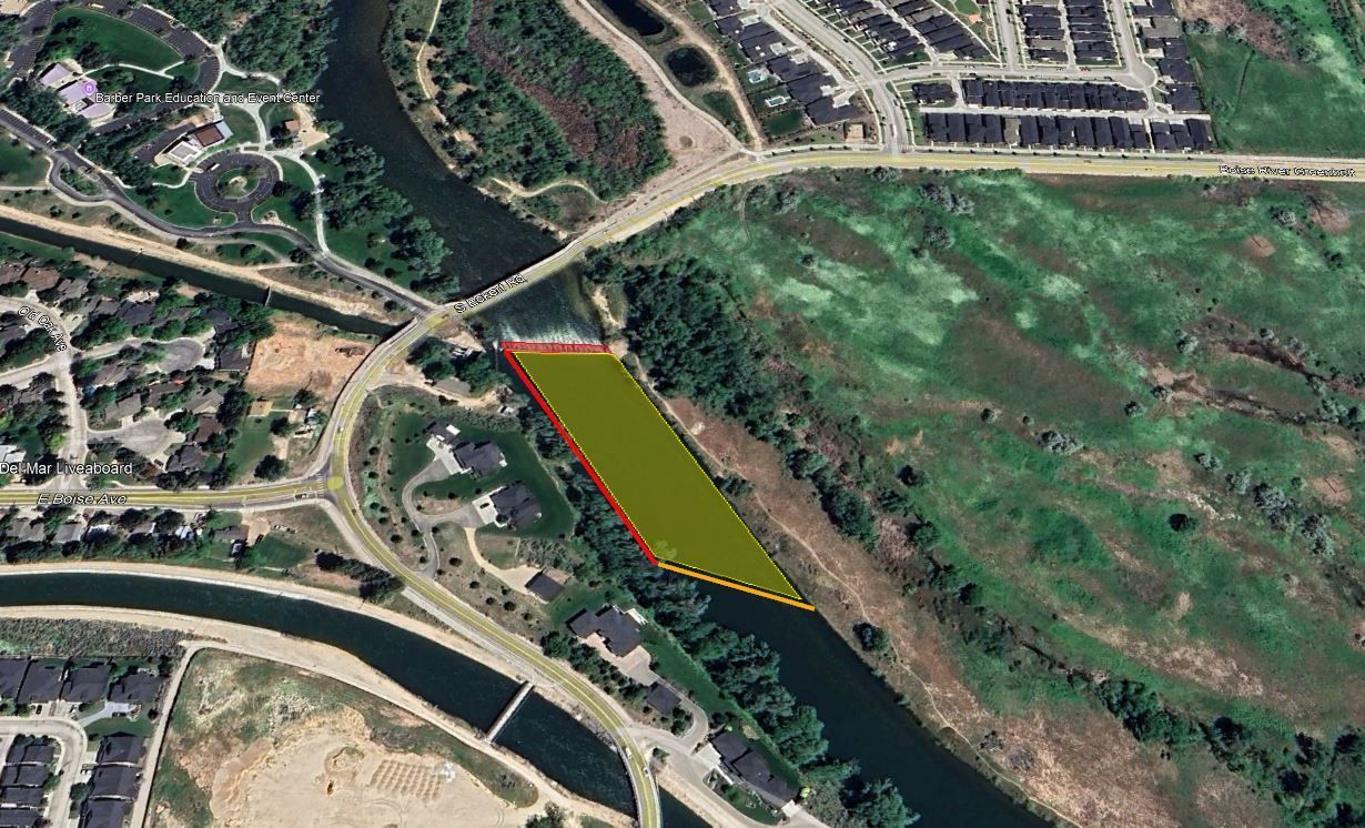
Above is my initial take of a best management practice at the Diversion in the Boise River. The existing backwater structure (Red Box) has a greater than 2' drop to it and was constructed in 1878. The canal begins over 500' from where the existing backwater structure is (Red Line). It is simple to assume that navigation of a structure back then wasn't needed... And this approach has continued to be "the operation" since 1878. This structure will be removed as part of the project. So a blank slate can be constructed for 500' of river!
In 2024, The Idaho Department of Water Resources now has the purview to approve such projects and require a less than 2' drop to meet Minimum Standards. This alternative places a navigable weir (Orange Line, ~300' long) across the river similar to that found at the Thurman Mill Diversion. This meets the less than a 2' drop criteria and provides opportunity for unique river experiences along with environmental benefits that can be incorporated.
The remaining drop can be used by the river using gradient instead of a drop (Yellow Box). This can be created after the crown and be approximately 500' long. A 2' drop over 500' would have a 0.40% gradient. This would likely be similar to the initiation rapids on the Upper Main Payette section, Whitewater 101 and 102.
A new structure would also be needed at the intake of the canal and could be the reconstruction of the red line to modernize it. Thiso that the water head will be maintained while the river has gradient to it. It can be a basic concrete stem wall.
What are your thoughts and ideas? hopefully a great asset for the community manifests.
P.S. A recent FERC document stated the Barber Dam 1 mile upstream of this rural area is in urgent need of action to avoid a Potential Failure Mode(PFM). This structure is approximately 30' tall and would likely cost Ada County a lot of money to get up to standard. The County has also been in a contingent contract with a private entity to pass ownership to. The site must get through FERC relicensing for the sale to complete.